PageList1

  • Iloilo City - Philippines!

    Integer vitae nulla!

    Cities have always been the natural economic units of theworld. But in the past several decades, what we once thought of as separatecities ?with central cores surrounded by rural villages, or later bysuburbs ?have grown into "megaregions" composed of two or morecities, like the Boston-New York-Washington corridor. Richard Florida of www.bnet.com

  • SHANGHAI

    Suspendisse neque tellus

    The geographical location of this city makes this city a central place to be a major participant in the country's overall economic and financial portfolio. There are too many attractions in this historical city but the Bouskoura forest is the only natural attraction in the city. Not only this but there is so many other things to do and places to visit while having a family trip or a business tour to this attraction of Morocco. You can find a lot of foreign tourists in Casablanca and if you are traveling from London, you can easily book your cheap flights to Casablanca from London.- Allen Ross

  • Curabitur faucibus

    Curabitur faucibus

    A city usually consists of residential, industrial and business areas together with administrative functions which may relate to a wider geographical area. A large share of a city's area is generally taken up by houses, roads, and streets. Lakes and rivers may be the only undeveloped areas within the city. - www.knowledgerush.com

  • Daegu - South Korea!

    Curabitur faucibus

    In a big city, people have the best chance to study and work. There are many good universities to choose from in a big city. Moreover, when you graduate, you also find it easier to find opportunities to get a good job with a good salary. That is quite difficult in small cities or countrysides, where there are not as many many big companies and groups. Hence, many graduate students choose big cities to live and work. In short, it is where you can take advantage of a city's benefits for yourself.

Monday, June 27, 2011

Butuan: The Timber City of the South


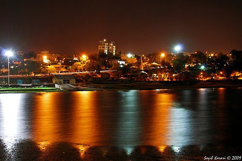
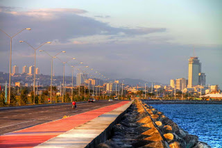
The City of Butuan is the regional center of Caraga an administrative region of the Philippines. It is located at the northeastern part of Agusan Valley Mindanao, sprawling across the Agusan River. It is bounded to the north, west and south by Agusan del Norte, to the east by Agusan del Sur and to the northwest by Butuan Bay. According to the 2007 census, it has a population of 298,378 people.

The name "Butuan" is believed to have originated from the sour fruit "Batuan"(Garcinia morella). Other etymology sources say that it comes from a certain "Datu Buntuan", a chieftain who once ruled over Butuan.

Butuan was the capital of Agusan del Norte until 2000 when Republic Act 8811 transferred the capital to Cabadbaran City. However many of the provincial government offices are still located there, including the provincial capitol, as are many the Caraga regional offices of the national government agencies. 

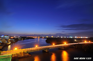
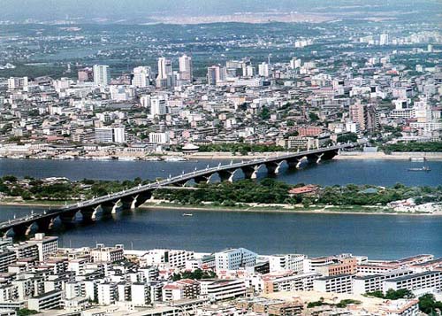
The name "Butuan" is believed to have originated from the sour fruit "Batuan". Other etymology sources say that it comes from a certain "Datu Buntuan", a chieftain who once ruled over Butuan. The City of Butuan is the regional center of the Caraga Region in the Philippines. It lies flat along the banks of Agusan River following along course within the province of Davao del Norte, Agusan del Sur, Agusan del Norte and drains into Butuan Bay. Butuan serves a strategic center of the Northern Mindanao region. The fishing ground of Butuan is the Butuan Bay of which two coastal barangays are located. It extends some two kilometers to the sea and joins the Bohol Sea. These are barangays Lumbocan and Masao. 


OFFICIAL DETAILS:
City Head:
City Population: 307,942 as of 2009
City Land Area: 817.28 km2
City Classification: Highly Urbanized City

AWARDS & CITATIONS:


MONIKER/NICKNAMES:


LINKS FOR MORE ABOUT THE CITY HERE:
http://butuantoday.tumblr.com/
@ http://butuantoday.tumblr.com/
@ http://www.butuancityguide.com/

MORE OF THE CITY’S PIC HERE:


Wednesday, June 22, 2011

Tripoli: The Three Cities


Aerial View of Tripoli Libya
Tripoli is the largest city and capital of Libya. It is also known as Western Tripoli (Arabic: طرابلس الغرب‎ Ṭarābulus al Gharb), to distinguish it from Tripoli, Lebanon.
Tripoli /ˈtrɪpɵli/ is a Greek name that means "Three Cities". It is in Arabic: طرابلس‎ Ṭarābulus  pronunciation (help·info), Libyan Arabic: Ṭrābləs  pronunciation (help·info), Berber: Ṭrables, from Ancient Greek: Τρίπολις Trípolis "Three Cities").

The Tripoli metropolitan area (district area) has a population of 1,065,405 (2006 census). The city is located in the northwest of the country on the edge of the desert, on a point of rocky land projecting into the Mediterranean Sea and forming a bay. The city is the principal sea port, and the largest commercial and manufacturing centre in Libya. It is also the site of Al-Fateh University.


Tripoli was founded in the 7th century BC by the Phoenicians, who named it Oea.[1] Due to the city's long history, there are many sites of archaeological significance in Tripoli.
The climate is typical Mediterranean, with hot, dry summers, and cool winters with modest rainfall.

"Tripoli" may also refer to the shabiyah (top-level administrative division in the current Libyan system), Tripoli District, also called the Tarabulus District.


OFFICIAL DETAILS:
City Head:
City Population:
City Land Area:
City Classification:
Website:

AWARDS & CITATIONS:


MONIKER/NICKNAMES:


LINKS FOR MORE ABOUT THE CITY HERE:


MORE OF THE CITY’S PIC HERE:


Monday, June 20, 2011

Santiago de Chile


Santiago de Chile is the capital and largest city of Chile, and the center of its largest conurbation (Greater Santiago). It is located in the country's central valley, at an elevation of 520 m (1,706.04 ft) above mean sea level. Although Santiago is the capital, legislative bodies meet in the coastal town of Valparaíso, a one-hour drive to the west.

Chile's steady economic growth has transformed Santiago into one of Latin America's most modern metropolitan areas, with extensive suburban development, dozens of shopping centers, and impressive high-rise architecture. It is an Alpha(-) World City and has a very modern transport infrastructure, including the steadily growing underground Santiago Metro, an effort at modernizing public bus transport and a free flow toll-based ring road and inner city highway system, part of which is tunneled underneath a large section of the city's main river Mapocho connecting the Eastern and Western extremes of the city in a 25-minute drive. Santiago is the regional headquarters to many multinationals, and a financial center. Santiago has a diverse, cosmopolitan culture. 


OFFICIAL DETAILS:
City Head:
City Population:
City Land Area:
City Classification:


AWARDS & CITATIONS:


MONIKER/NICKNAMES:


LINKS FOR MORE ABOUT THE CITY HERE:


MORE OF THE CITY’S PIC HERE:


Thursday, June 16, 2011

Santiago: The Trade and Commercial Center of Cagayan Valley Region

SANTIAGO CITY is the first component- independent city in the Cagayan Valley Region. Historically, the city was called “El Pueblo de Carig” by the Spanish Dominican Friars who started colonizing and christianizing the natives of the pueblo in 1597.

The City of Santiago is a 1st class city in the province of Isabela, Philippines. According to the latest census, it has a population of 126,244 people in 22,401 households. Santiago is situated 79 kilometers south of Ilagan, the provincial capital, and about 326 kilometers North of Metro Manila. The city sits on a vast area of predominantly flat and fertile land in the Cagayan Valley, surrounded by the Caraballo Mountains to the south, the Great Sierra Madre to the east and the Cordillera Mountain Range to the west.

The earliest reference to the existence of Santiago de Carig was contained in the documents found in the Dominican Archives of the University of Sto. Tomas that mentioned the Iyogads as contemporaries of Santiago de Carig’s early population which consisted mainly of Ibanags and Gaddangs.


It was formerly a barrio of Echague. The towns Cordon, Diffun, Saguday, San Mateo and Ramon were formerly its barrios.

The first five barrios after the Cadastral survey in 1927 were Patul, Batal, Nabbuan, Buenavista and Dubinan.

The area bounded by the Provincial road on the NW Carreon St on the SW Abauag St on the NE and the lot of the Methodist on the SE was the site of the first public school building before it became a market site.

Another favorable point confirming the existence of Santiago de Carig before 1743 was the DECREE of request issued on October 30, 1713 which required the inhabitants of Carig, together with those of Cordon, Diffun and Sta. Barbara de Lappao to give rice and money to the missionaries of the Holy Rosary in the province run by the Sacred Order of Preachers with headquarters in Ituy and Paniqui.

The term Pueblo ascribed to Santiago de Carig in the foregoing statement refers to the pre 1743 status as a mission pueblo and not as a Spanish name of “Santiago de Carig” in honor of St. James the Apostle whose feast day is celebrated July 25, back in 1743 and most probably earlier than that.


Further, historical records show that the Municipality of Santiago was officially created by Royal Decree on May 1743.


Santiago became the first city in the region through the enactment of RA No. 7720 on May 5, 1994 converting the then municipality of Santiago into independent-component city. Considered as the “Trade and Commercial Center of Cagayan Valley Region”, its strategic location makes it an important destination for businessmen or would-be investors and tourists.


Santiago City is 328 kilometers from Metro Manila and is accessible by land from any point in Luzon. The city is strategically located and considered a melting pot, all roads in the four provinces of Cagayan Valley Region lead to and out of it. And the influx of people and goods make the city the center of trade and commerce in the region.


Year 2000 census showed that Santiago City had a population of 110,531, half of which are living in the urban areas. The city has an annual growth rate of 2.5 percent. The city covers an area of 255 square kilometers with 37 barangays. 

   
OFFICIAL DETAILS:
City Head:
City Population:
City Land Area:
City Classification:

AWARDS & CITATIONS:


MONIKER/NICKNAMES:


LINKS FOR MORE ABOUT THE CITY HERE:


MORE OF THE CITY’S PIC HERE:


Tuesday, June 14, 2011

SAME NAME CITY 1: Santiago CITIES

Santiago de Compostela in Spain
"Santiago" as the name of th city is very famous in any parts of the world.  The name is a Roman Catholic influence. Below is the list of the cities which the official name included the world SANTIAGO:


1. Santiago de Compostela in Spain
2. Santiago de Cuba in Cuba
3. Santiago in Chile
4. Santiago del Estero in Argentina
5. Santiago de Veraguas in Panama
6. Santiago in Philippines
7. Santiago in Mexico

    Monday, June 13, 2011

    Sta. Rosa: The Lion City of the South

    The City of Santa Rosa (Filipino: Lungsod ng Santa Rosa) is a first class city in the province of Laguna, Philippines. It is also known as "The Lion City of the South" since 1994. The city lies 38 kilometers south of Manila via the South Luzon Expressway, making it a suburban residential community of Metro Manila.


    Santa Rosa was originally called "Barrio Bukol" of the Municipality of Binan, when the latter was discovered by the Spanish Conquistador Juan de Salcedo while exploring the Laguna Lake Region in 1571. Binan was later annexed to the town of Cabuyao to be separated from it in 1688. Barrio Bukol was then taken out of Binan and set up as a new political entity named Santa Rosa. It derived its name from its patron saint Santa Rosa de Lima of Peru which was reputed to have generously given material and spiritual blessings and favors to its devotees for the past 207 years.

    Composed of 18 barangays and 117 residential subdivisions (as of 2006), with a land area of 54.1 square kilometers, Santa Rosa is located in the south corridor of Luzon, about 45 kilometers south of Metro Manila, along the coastline of Laguna Lake. 

    It serves as a major gateway to the provinces of Batangas, Quezon, and Cavite via the South Luzon Expressway (SLEX). Its proximity to Metro Manila makes it a strategic site for domestic and international business, with Metro Manila’s Ninoy Aquino International Airport (NAIA) and the Manila International Container Port just an hour or two away. It is also within commuting distance from Makati, the country’s main business and financial center. 

    From a population of 41,335 in 1970, its number increased by 348 percent in a thirty-year period. Between the years 1991 and 2000, population increase was 200 percent. In 2000, Santa Rosa’s population was 185,000, with a population density of 4,427.6 persons per square kilometer (note: population stands at 266,943 per NSO’s latest survey of August 1, 2007). These increases are due to the high rate of in-migration from neighboring provinces and the spread of population caused by the urban sprawl of Metro Manila.

    The City of Santa Rosa (In Tagalog, Lungsod ng Santa Rosa) is a 1st class city in the province of Laguna, Philippines. It is also known as "The Investment Capital of South Luzon" since 1994. The city lies 38 kilometers south of Manila via the South Luzon Expressway, making it a suburban residential community of Metro Manila. This quiet town of Laguna started its progress initially from the establishment of Filsyn, CIGI and couple of other small multinational companies there when the government BOI provided for incentives to companies located at not less than 40 kilometers away from Manila. According to the 2000 census, City of Santa Rosa has a population of 185,633 people in 43,625 households but in 2005, it surpassed San Pablo City in terms of population, making it the fourth largest town or city in Laguna after Calamba City, San Pedro and Biñan.

    Highly Progressive - Home of Enchanted Kingdom,SM City,Robinsons,Ford Motors, Toyota, Honda, Nissan, Coke, Computer chip makers, Subdivisions(Ayala,Empire East, Brittany, StaLuciaRealty, Greenfield)


     OFFICIAL DETAILS:
    City Head:
    City Population:
    City Land Area:
    City Classification:

    AWARDS & CITATIONS:


    MONIKER/NICKNAMES:
    "The Lion City of the South"

    LINKS FOR MORE ABOUT THE CITY HERE:
    http://www.elcielito-starosa.com/
    @ http://www.santarosacity.info/

    MORE OF THE CITY’S PIC HERE:


    Friday, June 10, 2011

    CHINA: Top Four Tourists Cities

    The Skyline of Beijinng: China's Capital City
    Do you know that Beijing, Xian, Guilin and Hong Kong are the most visited cities in China?

    A lot of people refer it as the 'golden route' or 'presidential route' after Bill Clinton visited these cities in 1998. 

    Certainly the golden route has a good combination of everything: great historical heritages, beautiful landscape, delicious Chinese food, great shopping and so on.

    Best time to visit China is spring and autumn when China has beautiful weather and fewer tourists.

    If you are a first-time visitor to China, the golden route is your top pick. You would need at least two weeks to complete the tours.

    Beijing - you would need at least four nights to complete what you need to see and do.

    Great Wall China - the longest man-made architecture on earth. This should be your number one destination in Beijing. 

    Forbidden City - the former palaces and offices of Ming and Qing Dynasties. It is currently a museum with countless treasures. 

    Summer Palace - the most well preserved royal resort of Qing Dynasty.

    The Booming City of Xian in China
    Temple of Heaven is the symbol of Beijing. Ming and Qing emperors worshipped Heaven here.

    Please do include a hutong tour in order to have an old Beijing feel. After all, don't forget a Beijing duck feast.

    Tip: Beijing travel requires a lot of walking. Please be prepared for it.

    Xian - everyone should visit Xian at least once in life, Chinese and foreigners alike. Spend three nights here is necessary to cover the most important sightseeing.

    Xian has been a capital city for 13 dynasties, totaling 1,100 years. It was the world's most prosperous city in Tang Dynasty, 1300 years ago. 

    The Terra Cotta Warriors is a full-scale replication of the Qin Dynasty army. There is no other place in the world you can see a life-size army of over 2,000 years old.

    Banpo Neolithic village is a famous site of 6,000 years old which has typical features of a matriarchal society. You'll also see clues of ancient burial, marriages, creative tools and artifacts.

    Light Creates impact in Hong Kong
    In Xian, don't forget to go for a dumpling feast which usually goes with a first class entertainment show of Tang Dynasty music and dance.

    Guilin is ranked second on China's list of top 10 tourists' destinations. It has beautiful landscape integrated with fabulous countryside. Make sure you won't miss the Reed Flute Cave, the Crown Cave and some of the beautiful peaks.

    Don't forget to make a day trip to Yangshuo where the best hills and waters are. Go there on a Li River cruise and return by bus. If you choose to stay overnight, you would be able to watch the spectacular 'Liu Sanjie' performance, which takes place on the Li River. Yangshuo is truly a place for you to relax and enjoy.

    In Guilin, make sure to go for a rice noodle feast. Or you can just eat it as a street food at ¥2 per bowl. They are extremely yummy.

    Downtown Guilin and the Panorama
    A Guilin tour including Yangshuo would require a minimum stay of three nights.

    Hong Kong is very different from any other mainland Chinese cities. In Hong Kong, you can experience one-country-two-systems. I would suggest a minimum stay of three nights here.

    Being Asia's World City nowadays, Hong Kong is an important leg on the China travel golden route.

    There are several 'bests' of Hong Kong. The world's best night view, best skyline, best shopping paradise, best gourmet's paradise and so on. You would be able to buy the trendiest everything here at the lowest prices in the world, including authentic luxury goods. 

    Cantonese cuisine is one of the yummiest among Chinese foods. Don't forget to go for a dim sum lunch and a typical Cantonese seafood dinner.


    source:
    ============================================================

    Wednesday, June 8, 2011

    Winnipeg: The Heart of the Continent

    Winnipeg is the capital and largest city of Manitoba, Canada, and is the primary municipality of the Winnipeg Capital Region, with more than half of Manitoba's population. It is located near the longitudinal centre of North America, at the confluence of the Red and Assiniboine Rivers (a point commonly known as The Forks).

    Winnipeg is known as the city of festivals, which occur throughout the year, especially during the summer months. The Winnipeg Folk Festival is a legend around the world! Winnipeg is also home to a world-class ballet company, the Royal Winnipeg Ballet, the Winnipeg Symphony Orchestra, and several Opera and Theatre places. UNUM CUM VIRTUTE MULTORUM you will find on the Winnipeg's crest that means "One with the strength of many" in Latin.  

    The name "Winnipeg" comes from the Cree for "muddy waters". The Winnipeg area was a trading centre for Aboriginal peoples prior to the arrival of Europeans. The first fort was built there in 1738 by French traders. A settlement was later founded by the Selkirk settlers in 1812, the nucleus of which was incorporated as the City of Winnipeg in 1873. During the late 19th century and early 20th century, Winnipeg was one of the fastest growing cities in North America. The University of Manitoba, founded during this period, was the first university in Western Canada.


    Professional sports teams in Winnipeg are the Winnipeg Goldeyes (baseball), and the Winnipeg Blue Bombers (football). The many parks throughout 


    Winnipeg provide excellent opportunities for walking, biking, skiing and other recreational activities.  Winnipeg enjoys a lot of sunshine throughout the year. 


    The summers in Winipeg are typically very warm, dry and ready for Winnipeg festivals.  Winnipeg is located in Canada near the geographic centre of North America. Just about 100 kilometres from the American border, in the south central area of the Manitoba province. 


    OFFICIAL DETAILS:
    City Head: Sam Katz
    City Population: 633,451
    City Land Area: 464.01 km2 
    City Classification:

    AWARDS & CITATIONS:


    MONIKER/NICKNAMES:
    The Gateway to the West
    The Heart of the Continent
    The Peg

    LINKS FOR MORE ABOUT THE CITY HERE:

    MORE OF THE CITY’S PIC HERE:


    Sunday, June 5, 2011

    PHILIPPINES: The Next Dragon Cities in BPO Industry

    No. 4 is Metro Manila

    By Danny B. Dangcalan (The Philippine Star) 

    BACOLOD CITY, Philippines  – The information technology – business process outsourcing (IT-BPO) industry in the Philippines is growing by about 25 percent a year, and investors see the country as the “next Asian dragon,” Commissioner Ivan John Enrile Uy of the Commission on ICT (information and communications technology) said last week.

    No. 9 is Cebu City
    Uy said many of the world’s largest companies operate the biggest services centers in the Philippines, which is why the IT-BPO industry here continues to grow. As of last year, the industry employed about 525,000 people and had generated more than $9.1 billion in export revenues, he added.

    Uy, who was in Bacolod for the Negros Occidental First ICT Summit last Thursday, lauded Bacolod for being cited as the 3rd Next Wave City in the Philippines and Tholons International’s top 100th city in the world for outsourcing.

    No. 69 is Davao City
    “That is a very, very good accomplishment for Bacolod to be ranked among the top 100th out of thousands of cities around the world,” he said.

    Uy foresees that with the support of local officials the growth of the IT-BPO industry in Negros Occidental and Bacolod City will progress very fast.

    Uy said it is the goal of CICT to strengthen the readiness of cities and regions outside Metro Manila to become preferred destinations for IT-BPO investors.
    No. 88 is Sta Rosa

     “With this strategy, we will decongest Metro Manila, spread economic growth opportunities to other parts of the country, and capitalize on the abundant and globally competitive workforce available in many parts of the country,” he said.

    Approximately 20 percent of the IT-BPO industry is now located outside the main metropolitan areas of Manila and Cebu and this trend is expected to continue, he said.

    The country is now witnessing the impact of the IT-BPO industry on rural communities, as other cities outside Metro Manila emerge as new IT-BPO hubs or the Next Wave Cities, he said.

    No. 98 is Iloilo
    Uy pointed out that Tholons, a renowned international research firm, in its 2010 Top 100 Cities in the World for Outsourcing ranked Manila as No. 4 and Cebu as No. 9.

    The country’s Next Wave Cities that also made it on the list, are Davao - No. 69, Sta. Rosa (Laguna) - No. 88, Iloilo - No. 98 and Bacolod - No. 100.

    Meanwhile, Gov. Alfredo Marañon said the construction of IT buildings on lot properties owned by the Negros Occidental provincial government is expected to create about 41,000 new BPO jobs here.

    SM Prime Holdings has proposed to put up 10 buildings for BPO companies on a provincial government property along Gatuslao St. that will provide 40,000 jobs, he said, adding that the buildings will surround a convention center that SM plans to build in the area along with two hotels.

    No. 100 is Bacolod

    The provincial government is also establishing the Negros First CyberPark, a mixed-used complex consisting of more than 12,000 square meters of space for BPO services at a three-story building to be built at the Paglaum Sports Complex, which will provide more than 1,000 jobs, he added.

    Rep. Alfredo Abelardo Benitez (Neg Occ., 3rd District), who was also at the summit, said he will help tap government resources for infrastructure and academic support for the IT-BPO industry.

    Benitez also said he is supporting the efforts to create a Department of ICT, and the passage of bills to ensure data privacy and to curb cyber crime.

    source: